The S5PVAL-DE-Ruhr campaign, planned for summer 2020, is a collaboration between IUP-Bremen, Free University of Berlin, Max-Planck-Institute for Chemistry Mainz and BIRA, aiming at the validation of the Sentinel-5p nitrogen dioxide product.
The campaign takes place in Germany’s most populous federal state North Rhine Westphalia and focusses on three target sites for airborne measurements covering regions with industrial (point source) as well as urban (diffuse) emissions or a mixture of both. These sites are located in urban agglomerations of Duisburg (51.44°N, 6.76°E), Cologne (50.94°N, 6.97°E) as well as the Rhenish lignite mining district (50.92°N, 6.51°E), comprising three large power plants in Germany.
The airborne imaging DOAS instrument AirMAP, developed at IUP-Bremen, will map the horizontal distribution of nitrogen dioxide (NO2) in an area of about 30x30 km2 within a time window of about three hours at a spatial resolution better than 100 m. The flights will be optimized to coincide with the overpasses of the Sentinel-5p satellite (S5p), so that the gapless-maps derived from AirMAP can be used for direct comparison to the S5p product.
The airborne measurements will be supported by ground-based stationary and mobile DOAS measurements performed by BIRA, MPIC and IUP-Bremen. In addition, direct Sun measurements will be performed by two Pandora instruments provided by NASA which are deployed in Cologne and on the premises of the Jülich research centre close to the power plants, which also hosts an AERONET station.
A similar setup has been previously used during the AROMAT and AROMAPEX campaigns where AirMAP mapped the horizontal NO2 distribution above Bucharest, Romania, and Berlin, Germany, respectively. Figure 1 shows an example of an AirMAP flight above Berlin.
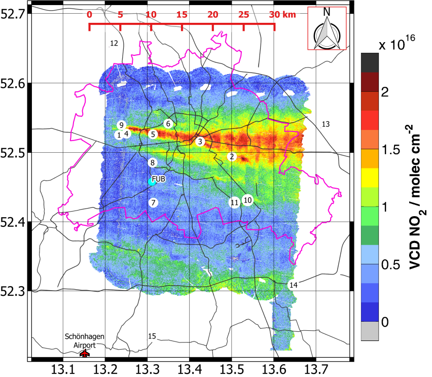
Figure 1: NO2 vertical column densities above Berlin measured by AirMAP on 2016-04-21 (Thursday) in the time interval 12:16 - 14:34 UTC. The flight pattern covers an area of 30km × 36km. Major roads (black lines) are overlaid for orientation. The pink outline shows the administrative boundary of Berlin. Numbered labels indicate large industrial emitters listed in the European Pollution Release and Transport Register (E-PRTR).
Publications
Schönhardt, A., Altube, P., Gerilowski, K., Krautwurst, S., Hartmann, J., Meier, A. C., Richter, A. and Burrows, J. P.: A wide field-of-view imaging DOAS instrument for two-dimensional trace gas mapping from aircraft, Atmos. Meas. Tech., 8(12), 5113–5131, doi:10.5194/amt-8-5113-2015, 2015.
Meier, A. C., Schönhardt, A., Bösch, T., Richter, A., Seyler, A., Ruhtz, T., Constantin, D.-E., Shaiganfar, R., Wagner, T., Merlaud, A., Van Roozendael, M., Belegante, L., Nicolae, D., Georgescu, L. and Burrows, J. P.: High-resolution airborne imaging DOAS measurements of NO2 above Bucharest during AROMAT, Atmos. Meas. Tech., 10(5), 1831–1857, doi:10.5194/amt-10-1831-2017, 2017.
Tack, F., Merlaud, A., Meier, A. C., Vlemmix, T., Ruhtz, T., Iordache, M.-D., Ge, X., Wal, L. van der, Schuettemeyer, D., Ardelean, M., Calcan, A., Constantin, D., Schönhardt, A., Meuleman, K., Richter, A. and Roozendael, M. V.: Intercomparison of four airborne imaging DOAS systems for tropospheric NO2 mapping – the AROMAPEX campaign, Atmospheric Measurement Techniques, 12(1), 211–236, doi:https://doi.org/10.5194/amt-12-211-2019, 2019.
For more information, please contact: Andreas C. Meier or Anja Schönhardt or This email address is being protected from spambots. You need JavaScript enabled to view it..
![]()
![]()
![]()
![]()