The S5PVAL-BE campaign, planned for summer 2021, is a collaboration between VITO and BIRA-IASB. The campaign will focus on urban and industrial emissions of nitrogen dioxide (NO2) in heavily polluted Belgian cities, i.e. Brussels (50°51'02" N, 04°20'56" E, 1.2 million inhabitants) and Antwerp (51°15'37" N, 04°24'10" E, 0.5 million inhabitants). Flights are also foreseen over the port of Antwerp, which is one of the biggest (petro)chemical clusters in Europe. The horizontal distribution of the NO2 trace gas field will be mapped based on hyperspectral Airborne Prism EXperiment (APEX) observations. During previous flights with APEX over Brussels and Antwerp in the framework of the BUMBA project, clear NO2 hotspots and strong horizontal gradients could be detected, related to traffic and industry. These city plumes can also be resolved in S-5p TROPOMI daily orbits. The flights (2 to 4 flights) will be carefully planned and optimized to coincide with the S-5p overpasses in order to fully cover multiple S-5p pixels (in the order of 10-25) with a short temporal offset, facilitating validation of the S-5p tropospheric NO2 product. In addition to the airborne component there will be a ground-based component, consisting of MAX-DOAS and mobile-DOAS instruments. A first successful nationally funded TROPOMI validation campaign has already taken place in summer 2019 and the new campaign, planned in 2021, will be based on the same consortium and will be built on the lessons learned.
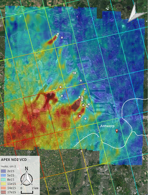
APEX tropospheric NO2 VCD grid retrieved over Antwerp on 27 June 2019. White dots indicate the point sources, emitting more than 10 kg of NOx per hour, according to the emission inventory (2017) of the Belgian Interregional Environment Agency. Line sources such as the key highways and city ring road are indicated by white lines. Coinciding TROPOMI tropospheric NO2 VCD retrievals are overlayed as color-coded polygons. White wind vectors indicate the surface wind, averaged over the APEX acquisition time. (© Google Maps).
Publications
Tack, F., Merlaud, A., Iordache, M.-D., Danckaert, T., Yu, H., Fayt, C., Meuleman, K., Deutsch, F., Fierens, F., and Van Roozendael, M.: High-resolution mapping of the NO2 spatial distribution over Belgian urban areas based on airborne APEX remote sensing, Atmos. Meas. Tech., 10, 1665–1688, https://doi.org/10.5194/amt-10-1665-2017, 2017.
Tack, F., Merlaud, A., Meier, A. C., Vlemmix, T., Ruhtz, T., Iordache, M.-D., Ge, X., van der Wal, L., Schuettemeyer, D., Ardelean, M., Calcan, A., Constantin, D., Schönhardt, A., Meuleman, K., Richter, A., and Van Roozendael, M.: Intercomparison of four airborne imaging DOAS systems for tropospheric NO2 mapping – the AROMAPEX campaign, Atmos. Meas. Tech., 12, 211–236, https://doi.org/10.5194/amt-12-211-2019, 2019.
Tack, F., Merlaud, A., Iordache, M.-D., Pinardi, G., Dimitropoulou, E., Eskes, H., Bomans, B., Veefkind, P., and Van Roozendael, M.: Assessment of the TROPOMI tropospheric NO2 product based on airborne APEX observations, Atmos. Meas. Tech. Discuss., https://doi.org/10.5194/amt-2020-148, in review, 2020.
Contact
For more information, please contact: This email address is being protected from spambots. You need JavaScript enabled to view it. or This email address is being protected from spambots. You need JavaScript enabled to view it.
![]()
![]()